Understanding Category 1A Land Title Surveys
A Category 1A Land Title Survey, is a specialized type of boundary survey with standards set forth by the Texas Society of Professional Surveyors (TSPS). The TSPS has created and published a Manual of Practice titled, “TEXAS SOCIETY OF PROFESSIONAL SURVEYORS MANUAL OF PRACTICE FOR LAND SURVEYING IN THE STATE OF TEXAS”. In this manual, it details twelve (12) specific types of land surveys. The most common request we receive is for Category 1A surveys.
 Categories.
1A – Land Title Survey
1B – Standard Land Survey
2 – Route Survey
3 – Locative Survey
4 – Mortgage Loan Inspection
5 – Construction Survey
6 – Topographic Survey
7 – Horizontal Control Survey
8 – Vertical Control Survey
9 – Investigative Survey
10 – GIS Products
11 – Three-Dimensional Control Survey
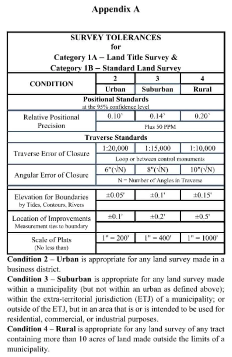
(Image is from the TEXAS SOCIETY OF PROFESSIONAL SURVEYORS MANUAL OF PRACTICE FOR LAND SURVEYING IN THE STATE OF TEXAS – 2021 Manual of Practice”
Typically when we are surveying a commercial property, the lender or buyer will request either an ALTA/NSPS survey or a TSPS Category 1A Survey. Lenders prefer these two types of specialized surveys because they know the survey tolerances and requirements are standardized and published so that the Registered Professional Land Surveyor overseeing the project will certify tolerances that are transparent for the client to view.
Benefits of a Category 1A Land Title Survey
A Category 1A Land Title Survey offers a comprehensive overview of a property, revealing not only its boundaries but also any potential issues or encumbrances that may affect its value or usage. The surveyor performing the survey will utilize a Title Commitment to aid in pulling relevant documents that detail easements or restrictions that may be located on the property. This information is vital in ensuring that title and ownership are clear, and any disputes are avoided.
This survey is a crucial step in the property-buying process, as it can disclose any potential roadblocks, such as encroachments or easements. For instance, it could reveal that a neighboring fence is situated on your property, or that the public has a legal right to walk through your backyard. These findings, while perhaps shocking, allow property owners to make wise choices and take necessary actions.
In addition to a final signed and sealed survey plat/map, the surveyor shall prepare a metes and bounds description of the property. The metes and bounds description, sometimes called a legal description, is a description of the property that uses bearings and distances to navigate a piece of the tract of land while describing adjoined and boundary corners. An exception to writing a metes and bounds description would be if the property is platted and the survey is in close agreement with the Lot’s platted calls.
Choosing a Professional Land Surveyor for your Category 1A Land Title Survey
Importance of consulting a licensed land surveyor
When it comes to property, it’s vital to ensure that you’re getting exactly what you’re paying for and that the boundaries are clearly defined. One reliable way to accomplish this is by hiring a professional land surveyor to survey your property.
NEED YOUR PROPERTY
SURVEYED?
Summit Geomatics, Inc. is a professional land surveying firm headquartered in San Antonio, Texas. Summit Geomatics, Inc. is a small business created to serve Central and South Texas by providing quality land surveying to our clientele.
We are here to serve your project’s specific needs from rush real estate closings to GIS mapping solutions. Our experience and unique skill set allows us to serve you by providing geospatial solutions tailor made for your needs.